What you get
Daily lane closure records
Log each closure with opening and closing time, location, and lane configuration. Pin it to the segment where the closure is active so the field crew and inspector see it on the map at the right place.
TCP coordination
Track the Traffic Control Plan in use for each segment. Link the plan sheet to the zone so field crews and inspectors see the same document tied to the closure location.
Flagging operation logs
Document each flagging shift: location, time, flagger assignment, and conditions. A dated, located record of every manual traffic control operation that is ready when the inspector asks.
Detour and alternate route tracking
Log active detours on the map with start and end locations. Field crews and the public works agency see where traffic is being diverted and why, without a separate coordination meeting.
Work zone boundary mapping
Define the extents of each work zone as a zone overlay. The project map shows active work zones, lane closures, and detours in one geographic view so everyone shares the same operational picture.
Why not spreadsheets, sticky notes, or memory?
- A spreadsheet does not show you that two closures overlap on the same segment at the same time.
- Lane closure logs in email chains are not visible to the crew starting work at 5 am.
- MOT compliance documentation needs a date, time, and location. A row number is not a location.
- When the inspector asks about a specific closure at a specific station, a spreadsheet makes you search.
See it in action
An I-15 southbound closure near Baker, CA — CMS sign placed 1,200 ft ahead, arrow board at taper entry, dashed cone line through the work zone, and an AFAD at the far end. Every element pinned at its exact GPS coordinate.
Lane closure records tied to the segment
A lane closure at Station 42+50 is not the same as one at Station 18+00. When those records live in a numbered log, the station is just a text field. When they live on the map, the location is the record. The crew arriving at 5 am taps the pin, sees the TCP reference, confirms the configuration, and knows exactly what they are setting up before they touch a cone.
- Pin each closure to its segment or station
- Attach the TCP plan sheet directly to the closure record
- See all active closures on the corridor at once to identify conflicts
- Close out each closure with a timestamp and crew note when the lane reopens
TCP and MOT documentation that is ready when you need it
Agency inspectors and resident engineers do not schedule their requests. When compliance documentation for a closure from three weeks ago is needed in the next ten minutes, the record is already there with the attached TCP diagram, the flagging log, the time window, and the crew notes, all tied to the location on the map.
Approved TCP attached to the record
The plan sheet the crew is working from is attached to the closure pin. No separate folder, no version confusion. The approved document is on the record.
Flagging logs with time and location
Each flagging shift is documented with the location, start and end time, flagger assignment, and any field notes. One tap from the field when the shift ends.
Modification tracking
When the engineer approves a field modification to the TCP, log it against the same closure record with a note and timestamp. The history of every change is attached to the location where it happened.
Multi-contractor lane closure coordination
When the GC, the traffic control sub, and the utility sub are all working on the same corridor, lane closure conflicts are one of the highest-risk coordination gaps. Each contractor sees their own closure schedule but not the others. HeavyCivilHelper puts everyone on the same map so the full closure picture is visible before the trucks roll.
The agency inspector can access the live closure map from their vehicle without calling the GC for a status update. The resident engineer sees which closures are active and which are scheduled without waiting for a daily email.
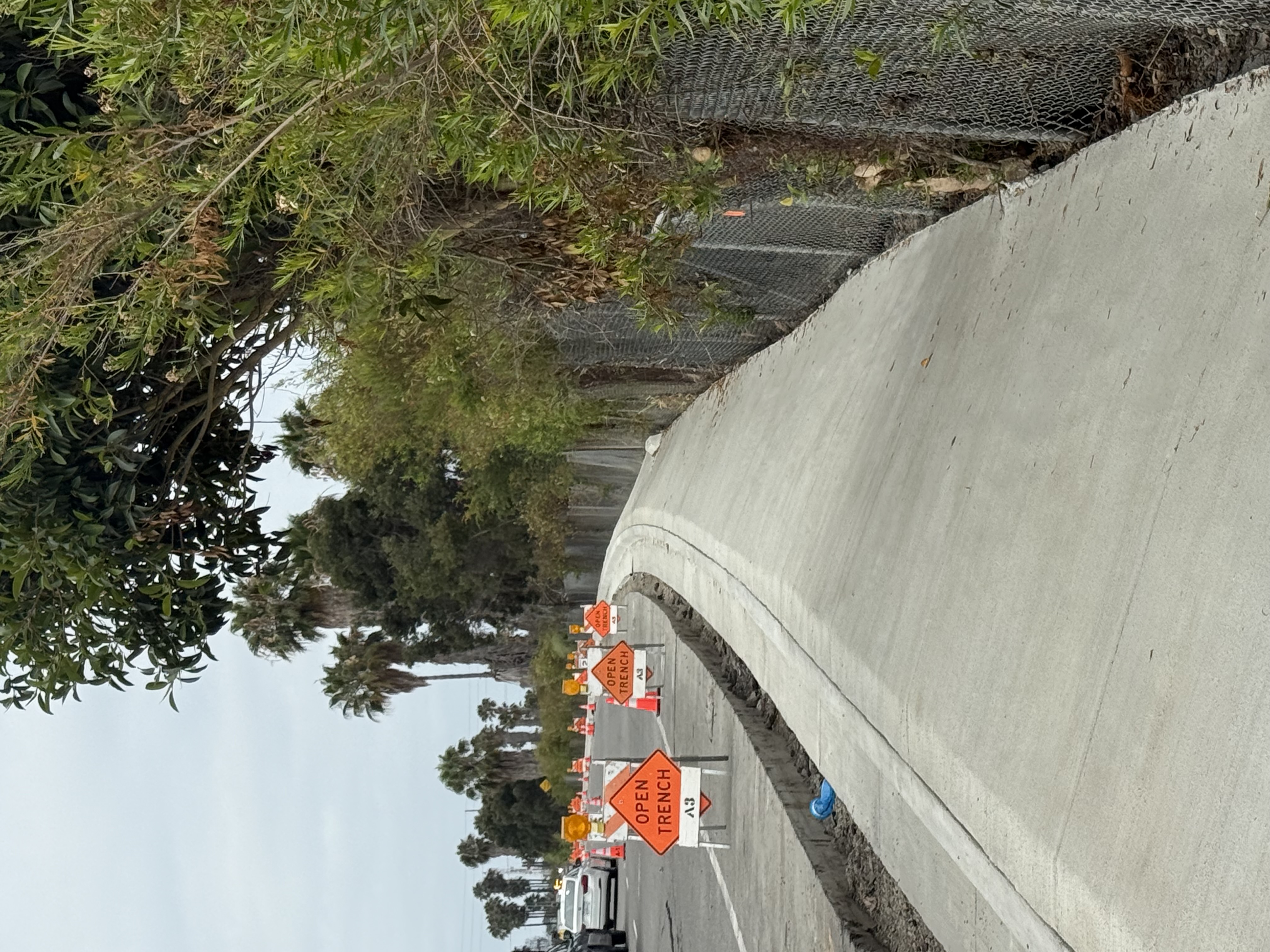
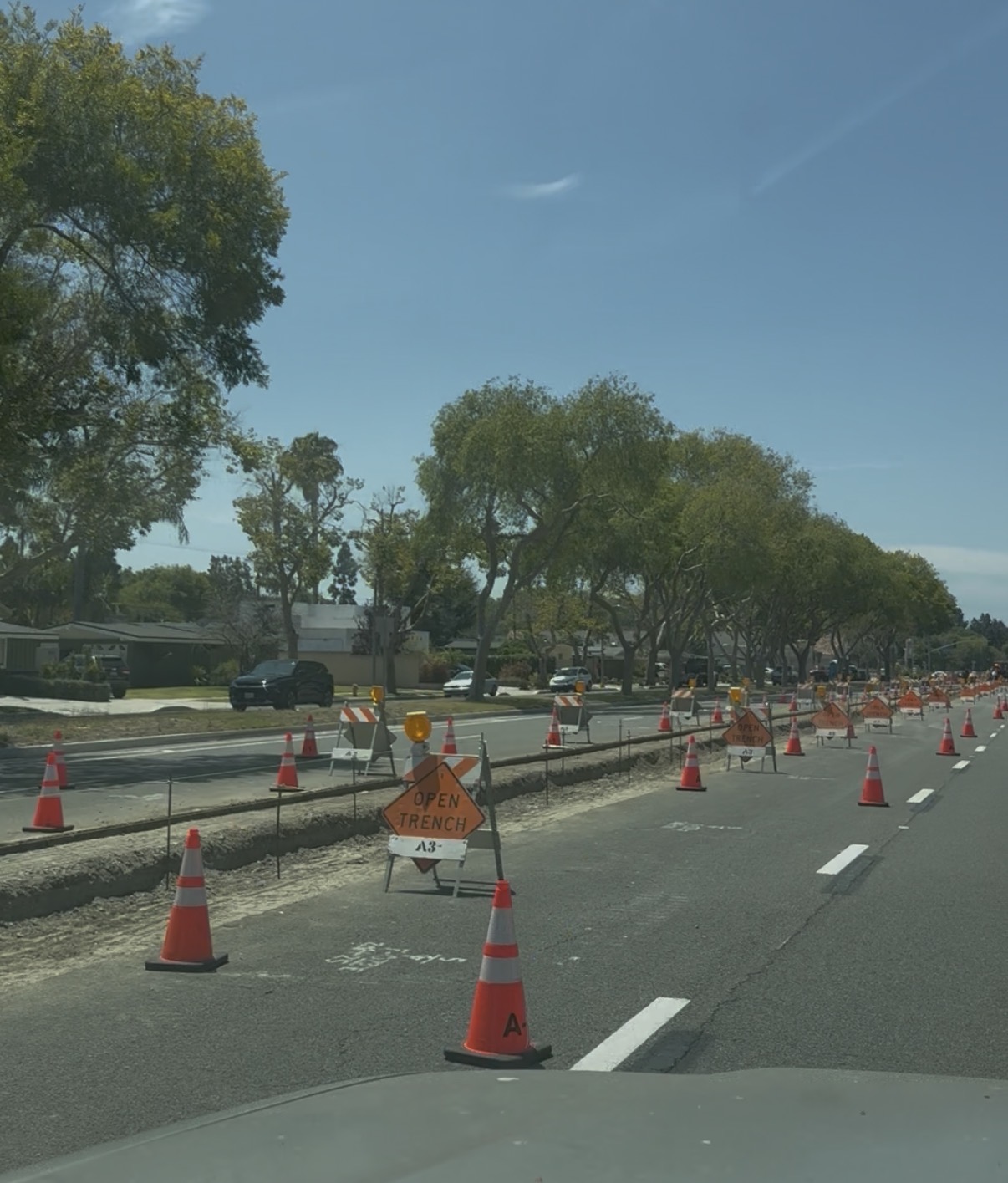
Both closures required coordinated TCPs, agency-approved signage, and daily lane closure logs — an open trench with fresh slope lining and a full median and #1 lane closure for median construction. In HeavyCivilHelper, each is logged as a pin at its station with the approved TCP attached and open/close timestamps recorded each shift.
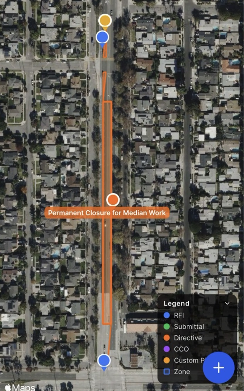
Lane closures tracked on the map — not in a spreadsheet
In HeavyCivilHelper, a lane closure is drawn directly on the satellite map as a zone over the affected segment. The orange corridor above shows the full extent of the median and #1 lane closure. A Directive pin at the center carries the TCP reference, approval status, and crew notes. The inspector, superintendent, and PM see the same live view from their phones — no status call, no shared drive search.
When the agency asks for compliance documentation, the closure record, the attached TCP diagram, and the open/close timestamps are all at the pin, organized by station.
Work zone example: cone line and open trench
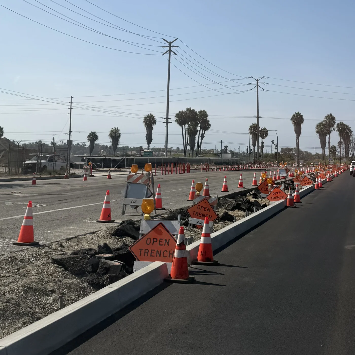
In this field example, cones and Open Trench warning signs separate an active median work area from the travel lane. A Traffic Control Plan documents the intended layout; crews can photograph the installed setup and log any changes against the closure record.
Work zone speed limits and covered signs
Construction speed limits are the enforced limit through a work zone — not a suggestion, not an advisory. When orange work zone speed limit signs are posted, that number applies regardless of any other speed limit signs visible along the same roadway. Fines for speeding in an active work zone are doubled in most states when workers are present, and some states double them regardless of worker presence.
Regular speed limit signs are sometimes covered with black plastic bags or trash bags when the posted limit no longer applies through a construction zone. The bag is a deliberate signal: that sign is suspended. The construction speed limit signs — typically orange or mounted on orange boards — are what governs.
When a bag has fallen off a covered sign
If the plastic cover has come off a speed limit sign, that sign is still not in effect — the bag falling off does not reinstate the old limit. The construction speed limit signs along the corridor remain the applicable posted speed. When conflicting signs are visible, always follow the lowest posted speed limit in the work zone. If you are unsure, slow down.
Safely traveling through a work zone — checklist for drivers
- Slow down at the first advance warning sign — the taper and lane shift begin before you expect it
- Follow the orange construction speed limit — it is the law in the work zone regardless of what other signs say
- If a bagged sign has lost its cover, the construction speed limit signs still govern — ignore the uncovered sign and follow the work zone posted speed
- Never pass a flagger — flaggers have the same legal authority as a traffic signal; a STOP paddle means stop
- Keep a four-second following distance — stopping distances do not shorten just because the speed limit does
- Stay in your lane through the taper — the merge point is signed, do not cut ahead of other vehicles
- Turn headlights on — required in active work zones in many states and increases your visibility to crew members
- Put the phone down completely — reaction time drops by 40% when distracted; work zones have sudden stops, lane shifts, and workers stepping out
- Watch for equipment swinging and backing — trucks and excavators have large blind spots; if you cannot see the operator's mirrors, the operator cannot see you
- Expect sudden stops — the vehicle ahead of you is navigating the same unfamiliar geometry you are
From the contractor side, ensuring work zone signing is correct and consistent is part of daily MOT coordination. Covered signs should be checked each shift to confirm bags are secure. Conflicting or missing signing is a compliance issue and a safety issue — log it as a record on the project map with a photo so the TCP manager can address it before the next crew arrives.
Common questions about traffic control tracking
- Does HeavyCivilHelper work for traffic control contractors specifically?
- Yes. Traffic control contractors use HeavyCivilHelper to log daily lane closures, document TCP operations, and track work zone boundaries by location on the project map. The pin-based system lets you attach the TCP diagram to the closure record so the field crew and project inspector share the same document tied to the specific segment where the closure applies.
- How do I log a daily lane closure in HeavyCivilHelper?
- Create a lane closure record, select the Lane Closure record type, and pin it to the segment where the closure applies. Add the time window, lane configuration, TCP reference, and any notes. The map shows every active and upcoming closure at a glance so you can spot conflicts before crews arrive on site.
- Can I track TCP compliance documentation in HeavyCivilHelper?
- Yes. Attach the approved TCP diagram, flagging logs, and any field modifications to the lane closure record. When the agency inspector requests compliance documentation for a specific closure date, the record is already there with the attached files, timestamp, and location on the map.
- What is MOT tracking software for construction?
- MOT (Maintenance of Traffic) tracking software for construction is a tool that logs each lane closure, flagging operation, detour, and work zone boundary as a dated, located record. HeavyCivilHelper uses the project map as the foundation. Each closure is a pin at the segment where it applies, with attached documentation and a status that shows whether it is active, scheduled, or closed out.
- How does HeavyCivilHelper help with lane closure coordination across contractors?
- When multiple contractors are working on the same corridor, lane closure conflicts are one of the biggest coordination risks. HeavyCivilHelper gives all parties access to the same project map so the GC, traffic control sub, and agency inspector can see all active and planned closures before conflicts happen. No separate spreadsheet to reconcile. Everyone sees the map.
- Can inspectors and agency staff access the traffic control records?
- Yes. You can share project access with agency inspectors and public works staff. They see the same map and the same lane closure records with attached documentation. No email threads, no version control issues. Everyone sees the current state of traffic control operations on the project.
See it on a real map
The interactive demo loads sample data so you can click through it in under a minute.
Related
Public Works and Heavy Civil
Roads, utilities, and infrastructure project tracking for the full project team.
What Is Field Coordination?
How field coordination works in construction and why map-based tracking helps.
Map-Based Field Coordination
How pinning every record to a location changes project visibility for the whole team.
Civil & Infrastructure Demo
See lane closures and field records on a real project map. No login required.