What you get
Name the category and pick a color
Create a category called 'Inspection Hold' in yellow, 'Bore Location' in blue, 'Compaction Test' in orange, or anything else your workflow needs. Each category gets a distinct color on the map so the foreman reads the status at a glance without opening each pin.
Define the status workflow
Set the exact status labels your crew uses — not a generic Open / Closed dropdown. A compaction test category might use Required, Scheduled, Passed, Failed. An inspection hold uses Hold, Inspector Notified, Cleared. You mark one status as terminal and pins that reach it move off the active view.
Add a checklist template
Each category can carry a checklist — a list of items that appears on every pin of that type. An inspection hold checklist might include: photos attached, inspector notified, response documented, hold cleared in writing. Each item is checked off individually and saved to the pin record.
Drop pins anywhere on the GPS satellite map
Once the category is built, any team member can drop a pin of that type at the exact GPS coordinate it applies to. The category color appears on the map immediately. The PM in the office and the inspector in the field see it at the same time.
Attach photos, notes, and files to each pin
Every pin supports photo attachments, free-text notes, and file uploads regardless of category. The foreman photographs the condition at the pin location. The inspector attaches the clearance document when the hold is resolved. All of it lives at the GPS coordinate.
Filter the map by category and status
Show only Inspection Hold pins to see every open hold across the project. Filter to Failed compaction tests to plan the next remediation sequence. The map collapses to exactly the information you need without any other pins in the way.
Why not spreadsheets, sticky notes, or memory?
- A numbered list of inspection holds has no map location — the foreman cannot find the hold without cross-referencing a drawing.
- Status updated in a spreadsheet at the end of the day is already stale by the time the next shift starts.
- A photo attached to a row in a spreadsheet has no GPS coordinate and no timestamp beyond the file metadata.
- When a project has 30 pins across 5 categories, a spreadsheet cannot show the PM a color-coded map view of what is open where.
- The inspector cannot clear a hold remotely — they have to tell someone, who updates the spreadsheet, which someone else then checks.
Built to fit how you work
Not a rigid system. A toolkit you configure.
HeavyCivilHelper gives you the core: map, records and plans. Add custom pin types for your workflow, draw shapes directly on the satellite map, and ask the AI questions using your actual project data.
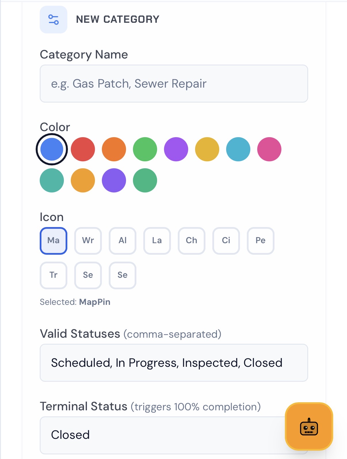
Custom Pins
Tracking Project Specifics? Name your category, pick a color, then define the full status workflow. Use HeavyCivilHelper to track Inspections, Utilities, Requests for Service, or more.
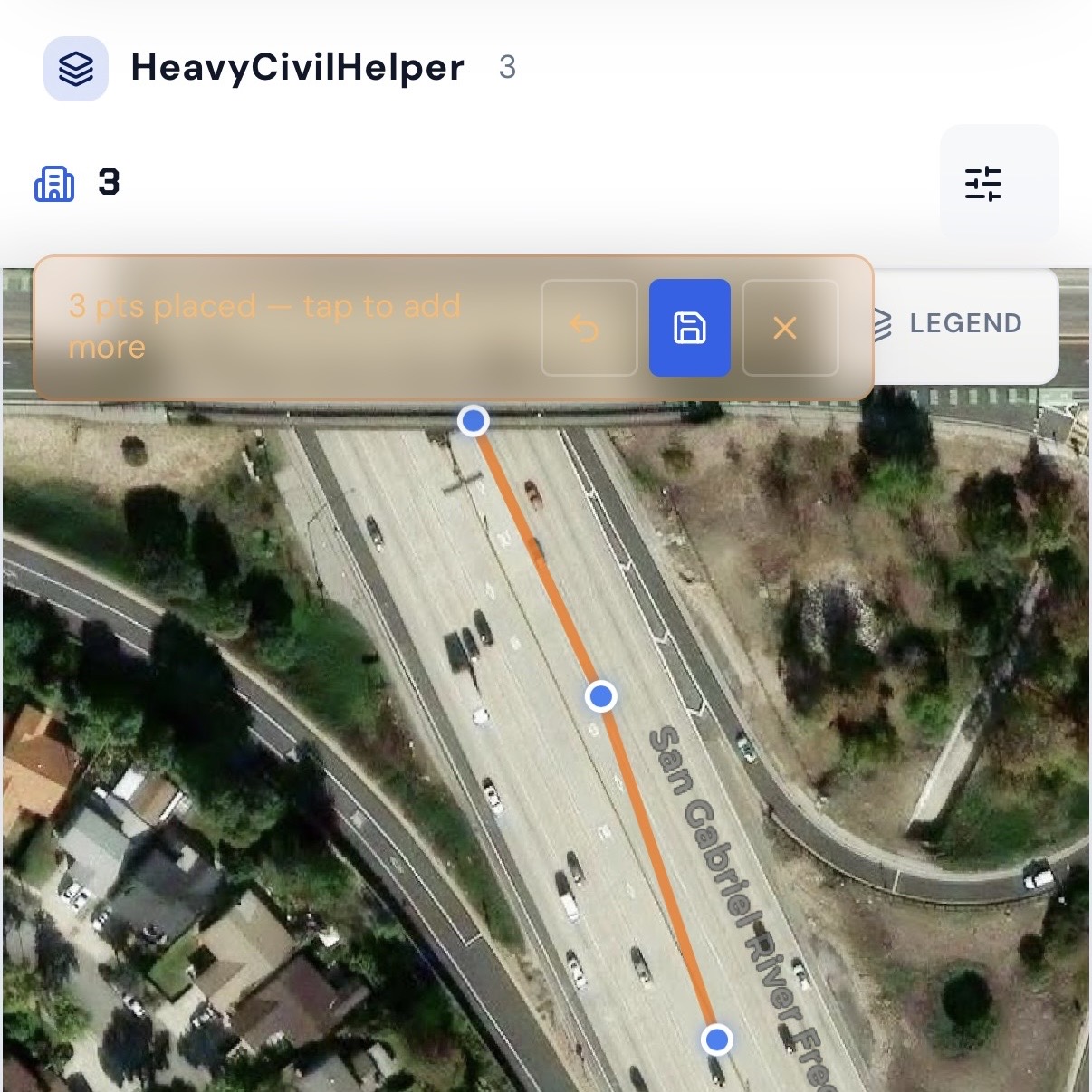
Lines
Tap to place points and draw a line on the satellite map. Use it for boundaries, lane closures, haul routes, utility alignment or any corridor that needs to be visible on the map.
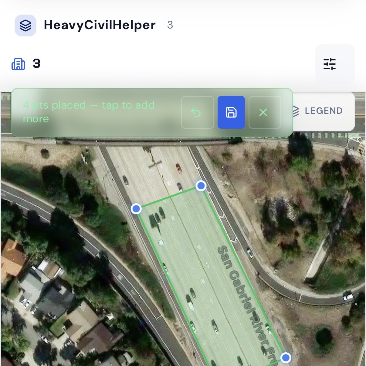
Zones
Draw a boundary around any area on the map. Name it and mark it as a Zone or Work Zone so your AI assistant knows exactly what falls inside it when you ask a question.
What contractors actually track with custom pins
These are real category types used on active projects in HeavyCivilHelper — not hypotheticals.
Inspection Hold
Hold → Inspector Notified → ClearedWork paused at a specific location until the inspector signs off. The pin stays yellow on the map until the inspector clears it. The PM sees which locations have active holds before scheduling the next phase — without calling anyone.
Bore Location / HDD Entry-Exit
Planned → Active → CompleteHorizontal directional drilling entry points, exit pits, and hand holes mapped to GPS coordinates. The engineer and inspector see the bore path relative to crossing utilities and permit boundaries on the same satellite view.
Compaction Test Required
Required → Scheduled → Passed → FailedEach backfill location where compaction testing is needed gets a pin. Status moves from Required through the test result. The inspector verifies which locations are cleared on their phone during the walk — no separate sign-off sheet.
Utility Conflict Zone
Discovered → RFI Submitted → ResolvedUnexpected utility found during excavation. Pinned at the GPS coordinate of the conflict with photos and depth notes. Status tracks from discovery through the RFI response that resolves the conflict.
Punch Item
Open → In Progress → Ready for Re-Walk → ClosedDeficiency items from the owner or inspector walk — each one pinned at the location of the deficiency. The sub updates status when the item is corrected. The GC verifies and the owner closes it during the re-walk on their phone.
BMP / Stormwater Control
Installed → Needs Maintenance → Maintained → RemovedBest management practices mapped to GPS coordinates for SWPPP inspection documentation. Each inspection notes the condition and any maintenance performed at the pin location — ready for the required inspection report.
Pavement Section
Scheduled → Milled → Overlaid → InspectedEach segment of a multi-section paving contract gets a pin. The foreman updates status in the field as work is completed. The city inspector confirms acceptance for each section on the map — no paper status sheet.
Custom pins in context: a live work zone on a freeway corridor
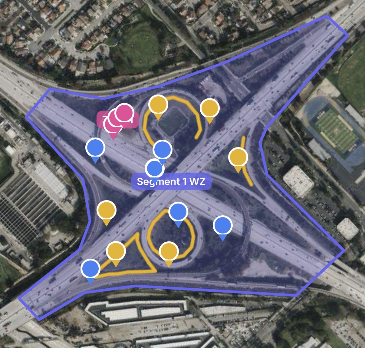
Custom pins distributed across a named Work Zone on a freeway corridor. The zone boundary tells the AI assistant exactly what is inside Segment 1 — every pin, every RFI, every open item — so when someone asks "what's open in Segment 1?" they get a real answer in plain English.
Common questions about custom pin categories
- What is a custom pin category in HeavyCivilHelper?
- A custom pin category is a map marker type you define yourself — you pick the name, color, icon, and status workflow. Once created, you drop pins of that category anywhere on the GPS satellite map. Each pin holds a status, photos, notes, checklists, and attachments. The category determines what the status workflow looks like and what the pin means in the context of your specific project.
- How is a custom pin different from an RFI, directive, or submittal?
- RFIs, directives, submittals, and change orders are structured record types with defined fields, numbering, and lifecycle workflows built into HeavyCivilHelper. Custom pins are flexible map markers for anything that does not fit one of those standard types. An inspection hold, a bore location, a compaction test point, a pothole reported by a resident, a BMP that needs a follow-up — those are the kinds of things that live as custom pins.
- What kinds of status workflows can I define?
- You define the status labels that make sense for your category. A compaction test category might use: Required, Scheduled, Passed, Failed. An inspection hold might use: Hold, Inspector Notified, Cleared. A punch item might use: Open, In Progress, Closed. One status is marked as the terminal status — when a pin reaches it, the pin is considered complete and moves off the active map view.
- Can I add checklists to a custom pin category?
- Yes. Each custom pin category can have a checklist template — a list of items that appear on every pin of that type. When a foreman opens an inspection hold pin, the checklist shows what needs to be verified at that location before the hold can be cleared. Checklist items are checked off individually and the completion state is saved to the pin.
- How many custom pin categories can I create?
- There is no set limit on the number of categories. In practice, most projects use between 3 and 10 custom categories alongside the standard RFI, directive, and submittal record types. Creating too many categories with similar purposes can make the map harder to read — distinct colors and clear naming keep the map useful.
- Can I see all pins of a specific category on the map at once?
- Yes. The map can be filtered by category, status, or both. You can show only the Inspection Hold category to see every open hold across the project, or filter to a specific status like 'Failed' across all categories to see which locations need attention before the next phase of work.
See it on a real map
The interactive demo loads sample data so you can click through it in under a minute.
Related
Construction Timestamp Camera
Add date, time, location, and map or blueprint context to photos that support inspections, punch items, BMPs, and other pin workflows.
For Utility Contractors
Custom pin categories for inspection holds, bore locations, conflict zones, and permit pending — built for underground utility field workflows.
For Paving and Pavement Contractors
Map grinding sections, overlay zones, and slurry seal status with custom categories across multi-site contracts.
What Is a Punch List?
How to configure custom pin categories as a GPS-based punch list for closeout tracking.
Public Works and Heavy Civil
How custom pins work alongside RFIs, directives, and submittals on public works corridor projects.
Try the Civil & Infrastructure Demo
Live project with custom pins, RFIs, and directives on an interactive GPS map.