Raken alternative for field coordination beyond the daily log
Raken is a daily reporting tool — and it does that job well. But a daily log answers "what happened today." It does not answer "which RFI is still open at Station 38, which directive changed the scope at that location, and what does the crew need to know before they start tomorrow." That is a different problem, and it is what HeavyCivilHelper is built for.
Many contractors use Raken for their daily reports and a separate spreadsheet for everything else: RFIs, directives, submittals, and open issues. HeavyCivilHelper replaces that spreadsheet with a live GPS map — so every open item is pinned to the location it applies to, visible to the whole team in real time.
Honest framing
This comparison is not "HeavyCivilHelper is better than Raken." Raken is a daily reporting and field log platform built around digital daily reports, time cards, toolbox talks, and safety documentation — designed to replace paper field logs and give superintendents a faster way to document what happened on site each day. If your primary need is faster daily report creation, digital time cards, toolbox talk documentation, and safety logs, Raken is a solid and widely-used tool for exactly that. It solves the daily reporting workflow cleanly. HeavyCivilHelper is a map-first field coordination layer — a different tool for a different workflow.
The daily log is not the same as the field coordination record
A daily report documents what happened. A field coordination system tracks what is still open and what needs to happen next. Most contractors who use Raken also maintain a separate RFI log, a directive list, and a submittal tracker in spreadsheets. HeavyCivilHelper consolidates those into one GPS map — so there is one place where the whole team sees what is open, what is overdue, and where the risk is concentrated on the project.
How the workflows differ
Raken captures what happened today. HeavyCivilHelper tracks what is still open and where it is on the map.
A daily report is a point-in-time record: labor count, equipment on site, weather, production notes, safety items, and a summary of the day's work. Raken's mobile interface makes capturing that information faster and more consistent than paper logs. If your goal is to stop losing daily reports and give the office a clean daily record, Raken solves that.
Field coordination is an ongoing record: an RFI opened at Station 28 two weeks ago is still open. A directive issued at the intersection last Thursday changed the median design. A submittal for the storm drain material is pending. These items do not close at the end of the day — they accumulate until they are resolved. Managing them requires a different tool than the one that captures daily progress.
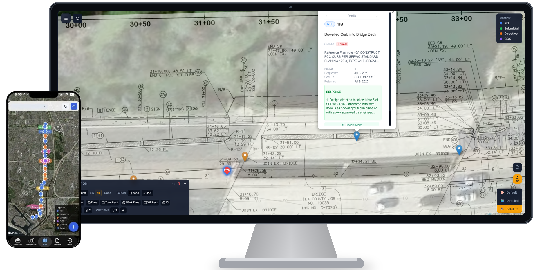
HeavyCivilHelper puts every open RFI, directive, submittal, and field issue on a live GPS satellite map pinned to the location it applies to. When the field team opens the app at a station, they see what is active at that location — not a dated log of what was documented last Friday.
Why teams start looking for a Raken alternative
Raken is a well-built platform. The mismatch shows up when the tool was designed for a different team size, workflow type, or level of geographic visibility than the one you are running.
Daily reports do not track ongoing open items
Raken's core workflow is the daily report: one document per day per project. RFIs, directives, and submittals are not daily — they are ongoing records that stay open until resolved. If you are tracking those in a separate spreadsheet, you already need a second tool. HeavyCivilHelper is that tool, with a GPS map instead of a log.
No GPS map for field issues
Raken has no map-based interface. Field issues, RFIs, and directives are logged as text records without spatial context. On a corridor project where the work spans multiple stations, knowing that an RFI exists is less useful than knowing where it is. HeavyCivilHelper pins every record to a GPS coordinate so the field crew can see what applies at their current location.
Contractors who need more than daily reports outgrow Raken
Raken is ideal for smaller crews or projects where the daily log is the primary documentation need. As projects scale — more subcontractors, more concurrent RFIs, more directives — the gap between 'what happened today' and 'what is still open and where' becomes the more urgent problem. HeavyCivilHelper handles that gap.
Side-by-side comparison
| Feature | HeavyCivilHelper | Raken |
|---|---|---|
| Core purpose | GPS map-based field coordination: open items by location | Daily field reports and safety logs |
| RFI tracking | Each RFI is a GPS pin at the station where the conflict exists | Not a core feature |
| Directive tracking | Core record type pinned to where scope changed | Not a core feature |
| Submittal tracking | Submittals pinned to the structure they govern | Not a core feature |
| Daily reports | Not the focus | Core feature |
| GPS map interface | Every record is a pin on a live satellite map | No map interface |
| Open item tracking | Every open issue visible on the map until closed | Daily log entries — not ongoing open item tracking |
| Plan sheet overlay | Upload plans, overlay on GPS map at true coordinates | Not available |
Specific features and pricing vary by vendor and contract. This comparison reflects general platform positioning, not a comprehensive feature audit.
Who HeavyCivilHelper is for
Good fit
- +Civil contractors who track RFIs, directives, and submittals alongside daily logs
- +Teams managing open items across multiple stations or project segments
- +Contractors who need the field crew to see what is active at their GPS location
- +Public works projects where directives and RFIs accumulate over months
- +Supers who are tired of cross-referencing the daily report with a separate RFI spreadsheet
Not the right tool if you need
- -Teams whose sole need is faster digital daily reports and time cards
- -Toolbox talk and safety documentation as the primary use case
- -Crews who need time card and payroll integration above everything else
Map-based construction workflows extend beyond heavy civil
HeavyCivilHelper supports three construction workflows: Civil & Infrastructure for civil and public works coordination, Building & Trades for active residential, commercial, and specialty jobs, and Bids & Estimates for pre-award opportunities.
Residential and specialty trades
Roofing, exterior, and specialty jobs need active-job visibility by location so crews, scope, and field notes stay connected.
Civil and utility contractors
Water main replacements, fiber installations, and corridor work are points or segments on a map before they are anything else.
Pre-award estimating teams
Bid locations, opportunity stages, site visits, and follow-up dates benefit from a visible pre-award pipeline.
Construction-adjacent field vendors
Material, environmental, and traffic-control teams can keep active site work and field records tied to the job location.
Traffic control and MOT operations
Lane closures, flagging locations, and TCP compliance points are defined by their geometry on the road network.
Independent construction crews
Small construction and specialty-trade crews can organize estimates and active jobs around the places where work is happening.
Frequently asked questions
Is HeavyCivilHelper a replacement for Raken?
It depends on your workflow. If you use Raken exclusively for daily reports and do not need open-item field coordination, HeavyCivilHelper is not a replacement — it is a different tool. If you use Raken for daily reports and a spreadsheet for everything else (RFIs, directives, submittals, open issues), HeavyCivilHelper replaces the spreadsheet with a GPS map. Some teams use Raken for daily logs and HeavyCivilHelper for field coordination — they operate at different layers.
Can HeavyCivilHelper capture daily field logs?
HeavyCivilHelper is focused on field coordination records — RFIs, directives, submittals, change orders, and custom pins — not structured daily logs with time cards and toolbox talks. If daily reporting is a compliance requirement for your projects, you may want to run both tools or check whether Raken's daily reporting can handle your format.
What does HeavyCivilHelper add that Raken does not have?
GPS map placement of every field issue, RFI, directive, and submittal. Ongoing open-item tracking that persists until the record is closed — not a daily snapshot. Plan sheet overlay on a live satellite map. The ability for a foreman to open the app at a station and immediately see what is active at that location without searching through a log. RFI, directive, submittal, and change order lifecycle management with cost tracking.
How does HeavyCivilHelper handle the coordination that happens after the daily report?
The daily report captures what happened. HeavyCivilHelper captures what needs to happen next and where. Every RFI is open until the response arrives. Every directive is logged until it is incorporated into the work. Every submittal is pending until it is approved. Those records live on the map, visible to the whole team, until they are closed. The PM sees which stations have the most open items before the next day's work begins.
See the map-first field coordination layer in action
The heavy civil demo loads a real public works project with RFIs, directives, lane closures, and a plan sheet overlay on a GPS map. No login required.
Related
Public Works and Heavy Civil
How HCH handles RFIs, directives, and submittals on public works corridor projects.
What Is an RFI in Construction?
How RFIs work and how to track them without losing the paper trail.
Directive vs RCO in Construction
Field directives vs requests for change orders, and why both need documentation.
Map-Based Field Coordination
Why GPS-based organization changes how field crews and PMs track open work.
Why Field Coordination Fails
Root causes and how map-based tracking addresses the gaps.